Aerospace and Defense
Drone Perception
Development and Integration
Airborne camera, navigation, Edge inference, sensor fusion, and payload validation
By Ceri Nelmes
Tech Marketing Leader & Journalist | Building Brands at the Edge of What’s Next | Connect Tech & CTai Labs
Technical review: Rob Callaghan, Chief Product Officer, Connect Tech Inc.

Key Takeaways
- CTai LABS integrates the complete airborne perception path from optics and payload sensors through time, navigation, ai inference, fusion, outputs, and flight-representative validation
- Work can start with an idea, a payload envelope, existing imagery, a trained model, a navigation problem, a prototype aircraft, or a fielded payload that needs focused engineering
- Connect Tech Sentry-X2 Mini, Hadron, Super Hadron, GMSL camera platforms, and NVIDIA® Jetson™ carrier options provide deployment paths for Jetson modules
- NVIDIA TensorRT™, CUDA®, and Isaac™ ROS can accelerate supported aerial perception and navigation workloads where they fit the architecture
- Altitude, ground sample distance, motion, shutter behavior, atmosphere, small-object scale, vibration, time, calibration, SWaP, power, thermal design, and bandwidth are evaluated together
- CTai LABS integrates approved perception and decision-assistance functions within customer-defined flight, mission, and operator boundaries
CTai LABS helps aerospace and defense teams turn a drone-perception idea, existing payload, image dataset, navigation stack, or trained model into a deployment-ready airborne system on Connect Tech hardware. This page covers optics, cameras, GMSL and MIPI CSI-2 integration, EO/IR and approved payload sensors, timestamps, navigation metadata, calibration, visual odometry, detection, segmentation, tracking, NVIDIA® TensorRT™ optimization, data reduction, SWaP, power, thermals, vibration, simulation, flight-representative validation, release, and handoff. CTai LABS can start with only the observation or navigation goal, or join at any point to select sensors, bring up a payload, integrate a model, repair timing, reduce latency, migrate compute, or prepare the system for the next flight-test milestone.
Airborne perception begins with what the sensor can resolve
Altitude, slant range, focal length, pixel pitch, field of view, ground sample distance, exposure, shutter type, aircraft motion, vibration, atmosphere, lighting, target scale, compression, and viewing angle determine what information reaches the model. A detector cannot recover detail that the imaging geometry never captured. CTai LABS defines the sensing envelope and acceptable observation conditions before model performance is treated as a system claim.
Katkuri et al. (2024) reviewed 173 studies of deep-learning computer vision for autonomous UAVs and organized the field across sensing and inspection, landing, surveillance and tracking, and search and rescue. Recent surveys of real-time aerial detection also emphasize small objects, dense scenes, scale variation, edge-resource constraints, and the accuracy and latency trade space. Maitre, Martinot, and Tuci (2024) evaluated deep-learning visual control for UAV power-tower inspection, illustrating the need to connect segmentation performance to the motion behavior that consumes it.
Open modular standards can reduce integration ambiguity when the platform already uses defined profiles. The Open Group describes the SOSA® Technical Standard as a reference architecture spanning hardware and software for sensor systems. ANSI/VITA 65.0-2025 defines OpenVPX system profiles for modules, slots, backplanes, and development chassis. Connect Tech Graphite VPX places NVIDIA Jetson AGX Orin™ Industrial in a rugged 3U VPX single-board computer aligned with the SOSA standard, creating a path for Edge ai acceleration within a modular sensor architecture.
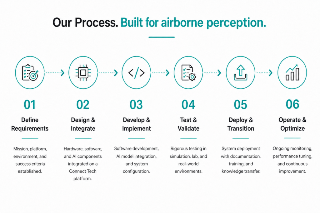
Figure 1. Drone perception must preserve image quality, time, navigation context, model evidence, confidence, and output timing across a SWaP-constrained airborne payload.
Engineer the airborne data path

Optics, cameras, and payload interfaces
CTai LABS can evaluate visible and approved thermal or other sensors, lens and field-of-view choices, global or rolling shutter, exposure, frame rate, triggering, stabilization, GMSL or MIPI CSI-2 camera paths, Ethernet, USB, and platform metadata. Connect Tech camera platforms support coax-based GMSL2 and GMSL3 configurations on compatible carriers, which can simplify power and data routing for remote cameras inside a larger payload.

Time, navigation data, and calibration
Geolocation, visual odometry, mapping, tracking, and multi-sensor fusion depend on known relationships among camera exposure, IMU and GNSS time, platform pose, gimbal state, transforms, and latency. CTai LABS maps those paths, establishes intrinsic and extrinsic calibration, measures delay and jitter, records navigation metadata with the imagery, and builds replay tools for analysis.

Small-object and real-time Edge inference
Aerial objects may occupy few pixels and appear across large scale changes and cluttered backgrounds. Cropping, tiling, image pyramids, temporal evidence, tracking, super-resolution, or model architecture changes can improve one part of the trade space while increasing latency, memory, or power. CTai LABS evaluates the complete task on representative flight data, then uses TensorRT and CUDA optimization where accuracy is preserved on the target Connect Tech hardware.

Visual navigation and degraded modes
Visual or visual-inertial navigation can degrade through blur, low texture, repeated patterns, altitude changes, dust, weather, saturation, occlusion, or camera loss. CTai LABS can integrate confidence, source health, estimator uncertainty, reacquisition, sensor fallbacks, output gating, and operator or controller interfaces within the customer-defined flight-control boundary.

Data reduction and scene understanding
Airborne bandwidth and storage may require local selection of clips, regions of interest, tracks, metadata, or summaries. CTai LABS can adapt the bounded scene-analysis pattern used in the Scene Analyzer Agent to approved aerial observation workflows, with a program-specific dataset, output schema, evaluation plan, and authority boundary. Raw source evidence and provenance are retained according to program requirements.
Architecture Through Deployment
The engagement can begin with a payload envelope and information goal, a camera shortlist, existing flight data, a trained model, a navigation stack, a Connect Tech platform, or a prototype that needs flight-representative evidence.
- Define the observation or navigation output, altitude and range, resolvable detail, environment, platform motion, flight and mission boundaries, SWaP, connectivity, and acceptance evidence.
- Select optics, cameras and sensors, Connect Tech hardware, NVIDIA Jetson™ module, interfaces, storage, time source, network, power, thermal path, enclosure, and mounting.
- Bring up the Board Support Packages (BSPs), sensors, navigation metadata, clocks, calibration, transforms, recording, replay, health monitoring, logging, update, and recovery.
- Integrate and optimize detection, segmentation, tracking, visual odometry, mapping, fusion, data reduction, and approved controller or mission-system outputs.
- Validate bench, vibration-representative, motion, recorded-data, simulation, HIL, tethered or controlled flight, degraded-mode, sustained-load, power, thermal, and recovery scenarios.
- Deliver the controlled release, calibration and configuration records, evaluation set, flight-test evidence, known limits, deployment procedure, and handoff.
Connect Tech hardware for drone perception
Drone perception hardware is selected from payload SWaP, camera interfaces, sensor count, model workload, storage, network, input power, cooling, connectors, and program evidence. Compact carriers suit custom enclosures, while rugged systems reduce integration work for larger payloads.
| Connect Tech platform | Drone-perception fit | Payload value |
|---|---|---|
| Sentry-X2 Mini with Jetson Orin™ NX | Compact rugged airborne payloads | IP67 MIL-rugged system with D38999 connectors, Ethernet, USB, and NVMe for bounded perception, navigation, and data-reduction workloads. |
| Hadron or Super Hadron with Jetson Orin™ NX | Custom SWaP-constrained payloads | Compact carrier paths with wide-input power and camera options where the program provides enclosure, thermal design, and qualification. |
| Connect Tech GMSL2 Plus or GMSL3 camera platform | Remote multi-camera payload integration | Up to eight compatible coax camera inputs on supported Jetson AGX Orin and Jetson Thor carriers, with power over coax and centralized processing. |
| Gauntlet with Jetson Thor™ | Larger high-compute aerial payloads | High camera and network bandwidth with Jetson Thor compute for concurrent perception and multimodal workloads, subject to platform SWaP and qualification. |
Example Drone Perception Projects
Airborne inspection and defect localization
A drone must inspect infrastructure while maintaining the image geometry required to detect and localize relevant conditions. CTai LABS defines the optics and route assumptions, integrates camera and navigation metadata, deploys detection or segmentation on Connect Tech hardware, and validates motion blur, scale, viewing angle, lighting, localization error, latency, and operator evidence.
GNSS-challenged visual navigation payload
A platform needs bounded visual-inertial estimation when GNSS quality falls below the approved threshold. CTai LABS integrates cameras, IMU, clocks, calibration, visual-inertial processing, health, confidence, and a controlled output interface, then validates texture loss, lighting change, aggressive motion, vibration, sensor loss, reacquisition, and compute load.
Bandwidth-limited aerial scene analysis
A payload cannot downlink all source imagery. CTai LABS deploys approved detection, tracking, event selection, metadata, clip creation, and store-and-forward behavior on Sentry-X2 Mini or a larger Connect Tech platform. The release includes evidence for source retention, provenance, confidence, bandwidth loss, storage limits, and recovery.
What CTai LABS can deliver
- Observation or navigation requirements, sensing geometry, environment, flight and mission boundaries, SWaP, connectivity, degraded modes, risk register, and acceptance matrix.
- Optics, sensors, Connect Tech platform, NVIDIA Jetson module, camera expansion, storage, time, network, power, thermal, enclosure, mounting, and connector architecture.
- BSPs and driver baseline, sensor and navigation-data bring-up, clocks, calibration, transforms, recording, replay, health, update, and recovery.
- Integrated detection, segmentation, tracking, visual odometry, mapping, fusion, data reduction, and approved controller or mission-system interfaces.
- Image-quality, geometry, task, confidence, geolocation, timing, sustained-load, power, thermal, vibration-representative, degraded-mode, and recovery evidence.
- Controlled release, model and data lineage, calibration and configuration records, evaluation set, flight-test evidence, known limits, and knowledge transfer.
Your Physical ai Integration Partner
CTai LABS connects Connect Tech airborne compute, camera and sensor interfaces, Board Support Package engineering, navigation context, Edge ai perception, data reduction, and flight-representative validation. The team can begin with an idea, solve one payload or perception boundary, or carry the approved drone-perception stack from architecture through deployment while the customer retains its intellectual property.
Book a Demo
Bring your goal. Start with the outcome your drone perception program must achieve. CTai LABS, a department of Connect Tech, can begin with an early idea, an architecture decision, a working prototype, a difficult integration issue, or a system that needs to become deployment-ready.
What to bring:
- The observation, navigation, inspection, or scene-understanding output and the approved consumer of that output.
- Aircraft and payload SWaP, altitude and range, field of view, environment, motion, vibration, connectivity, storage, and flight-test boundaries.
- Current or proposed cameras and sensors, Connect Tech hardware, NVIDIA Jetson platform, controller boundary, time and navigation sources, enclosure, and cooling.
- Flight imagery, annotations, models, calibration, navigation logs, source code, interface-control documents, performance traces, and test evidence.
- Accuracy, confidence, geolocation, latency, bandwidth, degraded-mode, environmental, cybersecurity, qualification, release, and lifecycle requirements.
CTai LABS uses these inputs to identify the highest-risk interfaces first and define the shortest credible path to a working, measurable system.

ABOUT THE AUTHOR
Ceri Nelmes
Tech Marketing Leader & Journalist | Building Brands at the Edge of What’s Next |
Connect Tech & CTai Labs
Ceri Nelmes is Head of Marketing at Connect Tech and an experienced technology journalist and digital strategist. She covers the technologies and market shifts shaping embedded computing, Edge AI, Physical ai, robotics, autonomous systems, and the NVIDIA® ecosystem. Working with Connect Tech and CTai LABS subject-matter experts, she turns engineering developments into accurate, useful reporting for developers, technical buyers, business leaders, and the media.
 Learn More
Resources and Frequently Asked Questions
Related
Aerospace & Defense. Explore CTai LABS capabilities for rugged compute, ISR, unmanned systems, and airborne perception.
Explore Aerospace & Defense →Rugged ai Computing. Design and integrate rugged Edge ai systems built to perform reliably in demanding aerospace and defense environments.
See Rugged ai Computing →ISR ai Integration. Integrate sensor data, ai models, and rugged Edge compute to support real-time intelligence, surveillance, and reconnaissance.
See ISR ai Integration →Unmanned Systems. Develop and integrate the compute, sensing, and ai systems required for autonomous and remotely operated platforms.
See Unmanned Systems →Scene Analyzer Agent. A pre-engineered Edge scene-understanding path that can inform approved aerial video workflows.
See Scene Analyzer Agent →Sources
Connect Tech. (n.d.). GMSL3 camera platform for NVIDIA Jetson AGX Orin and Jetson Thor. Retrieved August 21, 2026, from
https://connecttech.com/product/gmsl3-camera-platform-nvidia-jetson-agx-orin-jetson-thor/Connect Tech. (n.d.). Sentry-X2 Mini rugged system powered by NVIDIA Jetson Orin NX. Retrieved August 21, 2026, from
https://connecttech.com/product/sentry-x2-mini-rugged-system-nvidia-jetson-orin-nx/Katkuri, M., Madan, A., Khatri, N., Abdul-Qawy, A. S. H., & Patnaik, S. (2024). Autonomous UAV navigation using deep learning-based computer vision frameworks: A systematic literature review. Array, 23, 100361.
https://doi.org/10.1016/j.array.2024.100361Maitre, J., Martinot, P., & Tuci, E. (2024). On the design of deep learning-based control algorithms for visually guided UAVs engaged in power tower inspection tasks. Frontiers in Robotics and AI, 11, 1378149.
https://doi.org/10.3389/frobt.2024.1378149NVIDIA. (2026). Isaac ROS documentation.
https://nvidia-isaac-ros.github.io/Recent real-time aerial object detection approaches: A survey. (2025). Sensors, 25(24), 7563.
https://pmc.ncbi.nlm.nih.gov/articles/PMC12736610/Frequently Asked Questions
Can CTai LABS start before a drone camera is selected?
Yes. CTai LABS can begin from altitude, range, resolvable detail, field of view, motion, lighting, SWaP, and output requirements, then define the optics, sensor, interface, compute, and validation path.
Why are small objects difficult in aerial imagery?
They may occupy only a few pixels and vary greatly with altitude, view angle, motion, atmosphere, compression, and background. The imaging geometry and evaluation data must support the claimed task before model choice is finalized.
Can drone perception run without a cloud connection?
Yes, where the payload SWaP, cable, interface, camera, carrier, expansion board, driver, and enclosure support the architecture. Connect Tech offers GMSL2 Plus and GMSL3 camera platforms for compatible Jetson carriers.
Can CTai LABS integrate GMSL cameras on a drone?
Yes, where the payload SWaP, cable, interface, camera, carrier, expansion board, driver, and enclosure support the architecture. Connect Tech offers GMSL2 Plus and GMSL3 camera platforms for compatible Jetson carriers.
How is visual navigation validated?
Validation is scoped against the program’s acceptance criteria, including image geometry and ground sample distance (GSD), task performance on representative flight data, latency, sustained load, power and thermal behaviour, vibration-representative setups, degraded sensing, and known limits. Evaluation progresses from bench testing to recorded-data testing and, where included in the agreed scope, controlled-flight evidence.
Does CTai LABS automate flight or operational authority?
No. CTai LABS integrates approved perception and decision-assistance functions within customer-defined flight-control, mission, operator, legal, and safety boundaries.
Who owns the drone-perception data and models?
The customer retains its imagery, telemetry, models, application, platform design, and intellectual property. Engagement deliverables and licensing boundaries are defined in the statement of work.
Ready to Build Smarter?
Let’s create the intelligent Edge AI solution that moves your business forward.